Other than a quick trip to Half Dome a few weeks ago, the last time I spent time in Yosemite was around 2005, during a family trip. I’m told we stayed in Tuolumne Meadows, but I honestly do not recall anything about the scenery or where we visited – so earlier this year, I got a permit to explore Yosemite’s backcountry overnight.
My original plan was a simple loop using Cloud’s Rest starting and ending at Sunrise Lakes, but after finding a route in AllTrails that started at Sunrise Lakes and ended in Tuolumne Meadows and purported to hit “the best of Yosemite’s High Country” I changed plans.
After a quick night in the Cybertruck rooftop tent near June Lake, I drove in and picked up the permit and was able to find a ride right away to my starting trailhead, leaving the car at my end point. As I sent a message via my Garmin InReach to let Jacob know I was starting my trip, I realized there were two major problems: I had forgotten my trekking poles in my car (which was now miles away), and the buckle on my hip belt was broken. I briefly considered whether it was worth getting a hitch back to my car for the poles, or giving up, but instead thought it best to start and see how things went since there were lots of bailout points if things went south.


I started the drudging uphill to Cloud’s rest, thinking maybe it would have been worth it for the poles, but was easily distracted by good conversation with a passing hiker. He was an active duty Marine living in Colorado, and we traded concern about the deterioration of volunteerism and community spirit as well as about how he had decided last minute to make the trip, not even packing food due to lack of a bear can, and leaving at 3am to catch a flight after a 5 hour drive back to San Jose.


Cloud’s rest was gorgeous, easily a better view of the Valley than Half Dome, and including a good view of the Dome as well. After a few minutes of snapping photos, I said farewell to the Marine and continued onwards a mile or so to find a decent lunch spot since I hadn’t availed myself of any snacks due to the uphill and conversation. Luckily, there was a sub-dome with shade, no company, and beautiful views.
The hike down to Little Yosemite Valley from Cloud’s Rest was uneventful, and mostly retraced the same crowded steps I’d walked a month earlier doing Half Dome. One highlight was chatting briefly with an older couple visiting from Hungary (but faster than me) who were on their way to the “Diving Board” made famous by Ansel Adam’s photography in the 1920s, which required routefinding off-trail. The woman even offered me her belt buckle to replace my broken one – they were definitely tough stuff.
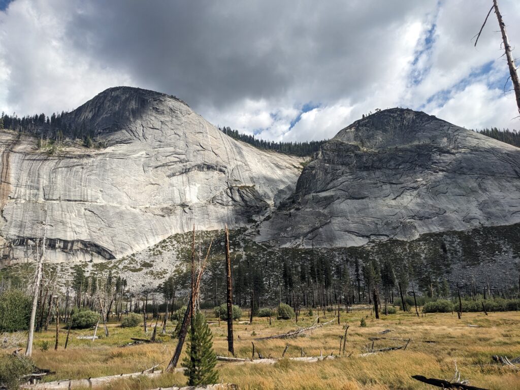
After leaving the crowded Little Yosemite Valley area and entering the burn scar of the 2014 Meadow Fire, morale was low due to heat, little shade, and dead trees. But, as I picked up some makeshift hiking poles and exited near Moraine Dome, things picked up.
When I had gotten my permit, the ranger mentioned it hit some of his favorite spots including the Bunnell Cascades (which I had never heard of). Following a long, hot hike through a burn scar, this ended up being my favorite stretch up until I reached Merced Lake the next morning.
The best way I can describe the Cascades is a series of small waterfalls which stretch over huge granite slabs like a giant slip and slide, landing in big deep pools – over 6 miles’ worth. The abundant water was definitely appreciated! Unfortunately, it’s also incredibly hard to photograph so hopefully this video makes it clear what I mean.
Despite Yosemite’s famed crowds, I did not see a single soul on the 8 mile stretch between Little Yosemite Valley and where I camped near Merced Lake. The beautiful Cascades, relatively easy terrain, but sweeping views made the end of Day 1 fantastic.


I woke up day 2 knowing it would be a tough one, both because of the significant altitude gain, and the fact that my right Achilles tendon was already complaining due to day 1’s exertions. I packed up and headed to Merced Lake, seeing my first fellow backpackers in over 16 hours, then began what can only be described as a slog up to Vogelsang Pass. Near the top, despite a 2 mile detour I took some time at Bernice Lake and enjoyed a swim (ok really just a dip in and out) entirely alone at over 10,000 feet. Thinking the climb so far hadn’t been hard, I continued on towards the pass only to find that pretty much all of the elevation had been saved for the final 1.5 miles!


The views from the top were of course incredible, and it felt good to know that vast majority of the trip’s elevation was complete, but the hopes I had harbored of maybe pushing through and getting to the car around dark had been completely crushed by how long the ascent took. After some quick pictures of Vogelsang Lake and Evelyn Lake, I grabbed some water and set up camp in a scant cluster of trees, knowing there was no way I’d sleep well due to still being over 10,000 feet and that there would likely be tons of wind on the open plain (I was right).
360 degree views from near my campsite by Evelyn Lake. Lots of varmints and even more wind!
The best part of waking up for day 3 was knowing that I had pretty much all downhill for only ~10 miles until I got back to the car. My Achilles was not in great shape and I had my first ever blister on my left foot, so I knew even then it wouldn’t be easy. Once I got over the plain’s ridge, it was all easy downhill through the forest past the turnoff for Ireland Lake, then connected with the John Muir Trail for several miles back to the parking lot. The last few miles were sunny, busy, and lacked water as well as significant views, so in my desire to get out quickly I did not hydrate well and got my first sunburn. Thankfully, Yosemite operates a small store near the trailhead so it was easy to grab a cold soda danget out of there!


Would I do this trip again? Absolutely not, unless someone I know wanted to do parts with me. While the views were amazing from Vogelsang pass, I’d seriously consider cutting that from a future trip and would definitely cut the portion from Vogelsang Lake past Evelyn Lake- it just wasn’t that scenic enough to justify the extra 5 miles vs. the Rafferty Creek trail. That said, I’m glad I pushed myself and saw a lot in one trip. Even though I’m not working at the moment, it’s still tough to take time “off” from the real world and leave all responsibility of home life to one person.
I learned that I need to keep getting better at doing altitude gain without killing my Achilles, and to figure out a better system for eating. I ended up lugging a lot of extra food I should have but didn’t eat, and didn’t even use my stove at all. In any case, it was only the second 2-night trip I’ve done, so if I solved at least the Achilles and got a bigger bear can it would be easier to extend things. While it was beautiful, I don’t think my next adventure will be in a National Park. Aside from being crowded unless you get really far in, I can’t take my dog Lucy, have to get permits, and plan ahead much more than other spots. We’ll see when I end up in Yosemite next!
- Trip type: Backpacking
- Distance: 40(?) Miles
- Altitude Gain: 9,000(?) Feet
- Length: 3 days, 2 nights
I’m gonna leave your first comment!
I think you did a great job of planning the trip (minus forgetting poles and the broken hip belt buckle. It is quite an accomplishment: 43.8 miles with 8920 ft of elevation gain, over 7 miles above 10,000 feet, and a suggested hike time of almost 22 hours. Great that you ran into a fellow hiker, the Marine from Colorado. Crazy that he had no bear can and had to drive all the way to San Jose to catch a 3 am flight back home! What an amazing view at Cloud’s rest! The valley and half dome all in one view! And not a bad view from your lunch break either! And all downhill to little yosemite valley. Great to pick up a pair of makeshift poles there, and it must have been tough going thru the 2014 Meadow fire area. I looked it up on wiki, and it’s recovered quite a bit “By 2020–2021, seven years post-fire, young pines and firs were visible in the burn area, along with flourishing wetland and meadow vegetation, following trends seen in Illilouette Basin.” Look like it is mostly on the south side of the Merced from google maps, and took out 5000 acres.
The Bunnell Cascades area looked very refreshing. I would sit in a shallow area next time! Sorry your Achilles tendon gave you problems… not surprising given all the elevation gain! The last day was all downhill, and like only ten miles as you said. Glad to see that you challenged yourself and what great scenery! Taking less food (like the marine!) is probably a good idea, especially on longer hikes.
Hey Laura!
Awed by your accomplishment and you took such lovely photos!
Sorry to hear about your Achilles tendon problems but you pushed through… doesn’t sound like you met up with many people or were troubled by huge crowds! Definitely an adventure and super useful if your time. I agree with Mike’s and your own assessment of taking less food!
Laura, I loved hearing about your hike in Yosemite, which is one of my favorite national parks(even better than Banff)
You gave a good description and I felt like I was hiking right along with you without having to kill my Achilles tendon(ha ha). You are very good photographer as well.! Would be great if you can get a job hiking and doing nature pictures! Have you thought about submitting the story anywhere?
Too bad you couldn’t have company with your dog along, but I suppose there’s a reasons for that! There’s something to be said and just doing a solo hike like you’re dead! I had a friend who backpacked solo many different sections of the continental divide Trail, as well as the Pacific crest! She loved hiking and she loved nature! She always seem to hook up with people that were very friendly and knowledgeable! That was great to have those German people help you out with your buckle!
I’ve had my share of adventures, but it’s great reliving these kinds of tracks without actually having to do them ! I don’t know if you’ve checked with having some physical therapy give you exercise exercises that would strengthen your Achilles?!
Anyway, thanks for sharing!!🙏🤩🙌👏🎈💕
Thanks, Sue – been doing a lot of exercises, I think it’s something to do with the way I walk uphill and the added weight exacerbates it. I’ve dealt with it in the past but thankfully after this trip it was back to normal faster than ever (only one day’s rest before I went out for a run)!